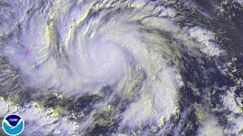
| Category 5 super typhoon (SSHS) | |
|---|---|

| |
| Krovanh at peak intensity while approaching the Philippines | |
| Formed | September 1, 2020 |
| Dissipated | September 29, 2020 |
| Highest winds | 10-minute sustained: 230 km/h (145 mph) 1-minute sustained: 270 km/h (165 mph) Gusts: 325 km/h (200 mph) |
| Lowest pressure | 869 hPa (mbar) (Second lowest pressure ever measured; after Choi-wan) |
| Fatalities | 8,923 confirmed, 10,328 missing |
| Damage | $143.5 billion (2020 USD) |
| Areas affected | Micronesia, Guam, Philippines, Taiwan, China, Japan |
| Part of the 2020 Pacific typhoon season | |
Typhoon Krovanh (also known in the Philippines as Typhoon Marilyn), was a very catastrophic and intense typhoon, as well as being one of the strongest tropical cyclones ever recorded in history. Typhoon Krovanh decimated portions of Southeast Asia, particularly the Philippines and Taiwan during early to late September, 2020. It is considered as the deadliest and costliest tropical cyclone to hit the Philippines, until later beaten by Super Typhoon Choi-wan two months later. The Typhoon also struck a major metropolitan area two weeks after a major earthquake hit.
Krovanh's predecessor can be traced back to an area of disturbed weather just west of the Marshall Islands on August 30, which then developed to a tropical depression two days later. It moved north to the northeast, and gradually shifted to the west in track. Gradually intensifying, Krovanh underwent a period of rapid deepening and explosively intensified from a Category 1 typhoon to a Category 4 super typhoon within 19 hours. Krovanh entered an area of moderate amounts of wind shear, and weakened to a Category 3 later that day, but Krovanh still attained a stadium effect. The next day, however, Krovanh re-intensified, and achieved it's title as a Category 5 super typhoon just to the south of Guam.
Krovanh maintained it's intensity and explosively intensified further. It's pressure dropped a whopping 31 mbars in just 16 hours. As the typhoon slowed down and shifted to the north, Krovanh attained a peak intensity with winds of up to 175 knots (325 km/h; 200 mph) with a pressure reading of 869 millibars, thus making it the strongest typhoon in terms of pressure, until beaten by Choi-wan two months later. On 932 EDT, the relentless storm moved ashore over Baras, Catanduanes at peak intensity. Making it's second landfall at San Jose, Camarines Sur, and making several other landfalls over different parts of Luzon.
Meteorological history[]

STY Krovanh's track
Krovanh's predecessor can be traced back to an area of disturbed weather spotted by the Joint Typhoon Warning Center (JTWC) on August 30, over an area of extremely favorable conditions just south of the Marshall Islands. It became a tropical disturbance the following day, as Japan Meteorological Agency (JMA) started to monitor the disturbance. On September 1, the disturbance was given a Tropical Cyclone Formation Alert by JTWC and was classified by JMA to be a Tropical Depression, as the system steadily organized. About an hour later, it was designated by the JTWC as 21W. On the 2nd of September, 21W has been upgraded to a tropical storm by JMA, as the JTWC followed suit. The tropical storm was assigned the name Krovanh. Krovanh executed a generally western track, as the storm was in the extreme southern periphery of s subtropical ridge.

Typhoon Krovanh as a newly upgraded Category 1 typhoon
Krovanh's intensification halted for 24 hours due to lack of upper-level divergence and dry air. As Krovanh maintained steady equatorial flow and organization, JMA prompted to upgrade Krovanh to a severe tropical storm. A day later, JMA upgraded Krovanh directly to a typhoon, as the storm showed a very efficient and imminent central dense overcast. A small, pinhole eye appeared at the center of the storm, as JTWC followed suit. The ridge weakened as the typhoon moved generally to the northwest. As it intensified further, JTWC upgraded the typhoon to a Category 2 in 16 hours, while JMA followed suit. The typhoon's eye drastically improved and widened; the convection over it's central dense overcast cooled dramatically, which prompted JTWC to upgrade it to a Category 4 typhoon, and soon a Category 5 super typhoon just south of Guam.
TBC~
