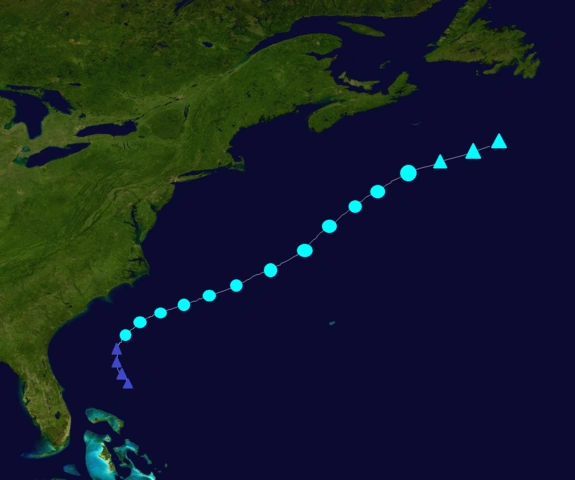
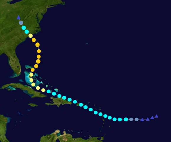
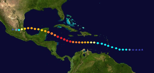
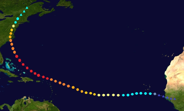
The 2101 Atlantic hurricane season was an extremely active and destructive season, with 41 depressions, 38 named storms, 28 hurricanes, and 12 major hurricanes forming. The season officially started on May 15 and ended on December 15. These dates conventionally delimit the period of each year when most tropical cyclones form in the Atlantic basin. However, the first storm, Alice, formed on February 6, 3 months before the official start of the season. There was also a storm, TS Gimel, that was active at the start of the year after forming in 2100. Hurricane Bobby also formed before the start of the season, on April 12.
This season was less active than last year, but was still exceptionally above average. This season was very devastating, with Gillian, Josh, Martha, Phil, Steven, Vick, Whitney, Charley, and Diana responsible for most of the destruction. The strongest and most destructive storm of the season was Steven, a Category 6 hurricane that devastated the Caribbean, Central America, and the US. It caused $405 billion dollars in damage and 41,524 deaths throughout its path, becoming one of the most devastating hurricanes in history. The other storms listed above were also very notable and also had their names retired.
Because of the extreme activity of the previous season, for this season, the NHC made the Q, U, X, Y, and Z names a permanent part of their naming lists. These additional names would rotate each year, with the same Q, U, X, Y, and Z names used in 2100 to be used in 2102, and the same Q, U, X, Y, and Z names used in 2101 to be used in 2103 (unless they are retired). The NHC also added a secondary naming list for this season and for future seasons, using names that were retired before the year 2050. This was because of the previous recent seasons (such as 2100, 2099, 2098, etc.) exhausting the main list and going onto the Greek Alphabet. 2100 was an extreme case, exhausting even the Greek Alphabet and going onto the Hebrew Alphabet. Now, because of this additional naming list, reaching the Greek Alphabet is much harder than ever before, with only 2100 having enough storms to exhaust the secondary naming list.
The season started with Alice, which formed in February, 3 months before the official start of the season. The next storm, Bobby, was a rare pre-season C1 hurricane that formed in April, making a rare occurrence of 2 named storms before the start of the season. Alice and Bobby didn't affect land.
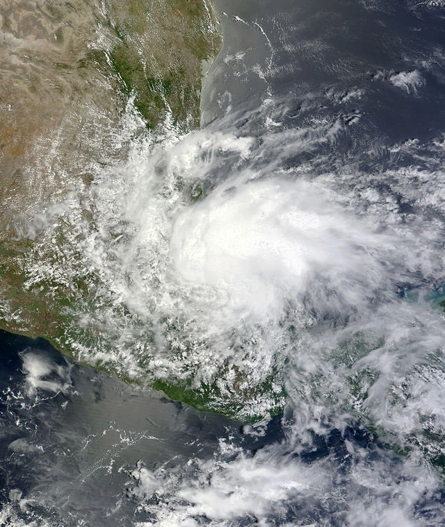
In May, 2 storms, Cassie and Dylan, formed. They both formed after May 15, the official start of the season. TS Cassie didn't affect land, and Dylan was a C2 that affected Mexico.
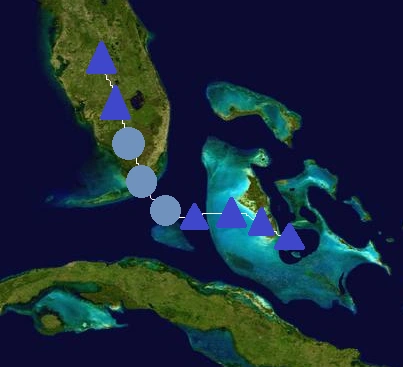
In June, 3 storms, Elizabeth, Fernando, and TD Seven formed. Elizabeth was a C2 that affected the Caribbean and the US East Coast, Fernando was a C1 that affected the Windward Islands, and TD Seven impacted Florida.
In July, 5 storms, Gillian, Henry, Ira, Josh, and Kim formed. Gillian was a C5 that affected the Caribbean and Mexico, TS Henry slightly affected Cape Verde, TS Ira affected the Carolinas and the US East Coast, Josh was a C3 that affected the northeast Caribbean Islands, The Bahamas, and the US East Coast, and TS Kim affected Mexico.
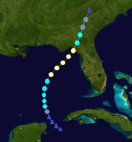
In August, 8 storms, Luke, Martha, Nathan, Olly, Phil, TD 18, Quincy, and Rebecca formed. C4 hurricane Luke affected Cape Verde, Bermuda, and Atlantic Canada, C5 hurricane Martha affected the Caribbean, The Bahamas, Florida, and the US Gulf Coast, TS Nathan also affected the US Gulf Coast, C3 hurricane Olly slightly affected the Windward Islands and Bermuda, C5 hurricane Phil affected the Caribbean, the Yucatan, and the US Gulf Coast, TD 18 affected Guyana and Venezuela, C1 hurricane Quincy affected Cape Verde, and finally Rebecca affected Mexico.
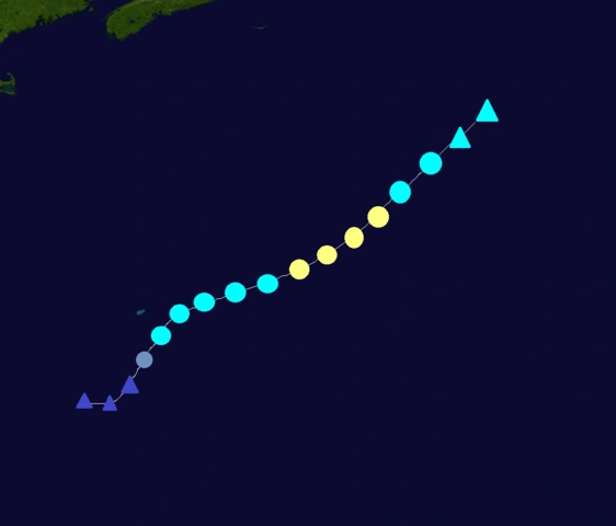
In September, 10 storms, Steven, Tammy, Utor, Vick, Whitney, Xina, York, Zelda, Andrew, and Beryl formed. C6 hurricane Steven was an extremely devastating hurricane that raged through the Caribbean, Central America, and the US, TS Tammy affected the Azores, C2 hurricane Utor didn't affect land, C4 hurricane Vick affected the Caribbean, Florida, and Atlantic Canada, C5 hurricane Whitney affected Cape Verde, the northeast Caribbean islands, and the US east coast, C1 hurricane Xina was a rare hurricane that affected Newfoundland and Greenland, C1 hurricane York affected Florida and Georgia, C2 hurricane Zelda affected the Caribbean and the US east coast, C4 hurricane Andrew was a Cape-Verde type hurricane that only affected Bermuda, and finally TS Beryl affected the Yucatan Peninsula, Cuba, Florida, and the Carolinas.
In October, 7 storms, Charley, Diana, Ernesto, Frances, TD 35, Georges, and Hortense formed. Charley was a C5 that affected Cuba, The Bahamas, and the US East Coast, C4 hurricane Diana affected the northeast Caribbean islands, The Bahamas, Florida, and the US Gulf Coast, TS Ernesto affected Mexico, C2 hurricane Frances affected Jamaica, Haiti, Cuba, The Bahamas, and Bermuda, TD 36 didn't affect land, Georges was a very rare C1 hurricane that affected the Canary Islands and Portugal, and Hortense was a C1 hurricane that affected Nicaragua, Honduras, Belize, the Yucatan Peninsula, and Mexico.
In November, 3 storms, Ivan, Joan, and Klaus formed. C2 hurricane Ivan affected the Yucatan and the US Gulf Coast, C1 hurricane Joan was rare in that it affected Venezuela, Colombia, and Nicaragua, and C1 hurricane Klaus affected Bermuda.
Finally, in December, Lili formed. TS Lili didn't affect land, and dissipated on Christmas Eve. Overall, this was a very devastating and active season.
Seasonal forecasts[]
Predictions of tropical activity in the 2101 season
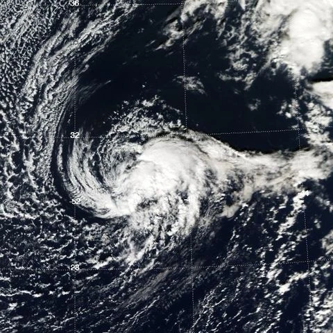
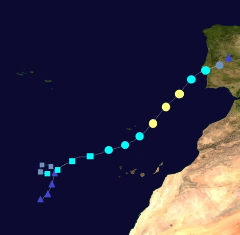
An extratropical cyclone formed on February 4 in the Central Atlantic. It gradually developed subtropical characteristics as it moved northwestward, and on February 6, it became a subtropical storm and was named Alice, skipping depression status. It formed unusually early, more than 3 months before the official start of the season. Alice turned westward and then southwestward while acquiring tropical characteristics. The storm became tropical late on February 7, and reached its peak of 60 mph and 998 mbar before reaching unfavorable conditions. It weakened to a depression early on February 9, and dissipated later that day. Alice didn't affect land.
The NHC began to monitor an extratropical cyclone north of the Lesser Antilles on April 11. It quickly acquired subtropical characteristics as it moved westward, and was declared Subtropical Depression Two the next day. The depression strengthened into a tropical storm and was named Bobby on April 13. Bobby turned northward and became tropical on April 14. It then turned northeastward and gradually strengthened. The storm became a hurricane early on April 16. It was a very rare April hurricane. Bobby then reached its peak of 80 mph and 978 mbar before turning northward and weakening. It weakened into a tropical storm on April 17 before dissipating early on April 19. Bobby didn't affect land.
An area of disturbed weather formed on May 16 north of the Bahamas. It gradually developed, and became Tropical Storm Cassie on May 18, skipping depression status. Cassie moved northeastward as it gradually strengthened. It reached its peak of 65 mph and 995 mbar before weakening. The storm became extratropical on May 21 south of Nova Scotia. Cassie didn't affect land.
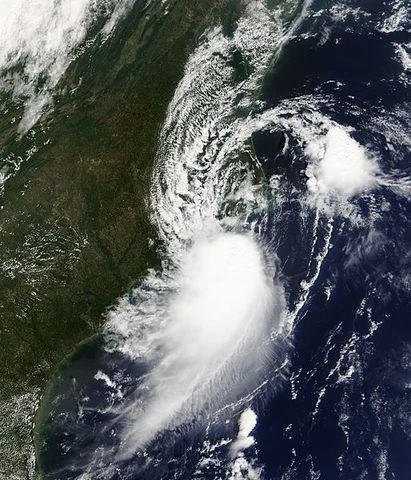
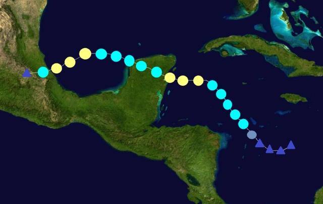
The NHC began to monitor an area of disturbed weather in the southwest Caribbean on May 22. It slowly developed and became a depression on May 24 as it moved northwestward. It then strengthened into TS Dylan that night. Dylan was predicted to strengthen under favorable conditions. It became a hurricane early on May 27 and turned more westward, and continued to gradually strengthen as it headed towards Belize and the Yucatan. Dylan later became a Cat. 2 and reached its peak of 105 mph and 968 mbar before making landfall in the Yucatan early on May 29 as a Cat. 1 hurricane. The storm quickly weakened over land and emerged into the Gulf as a disorganized depression. It restrengthened into a tropical storm and reached a secondary peak of 60 mph and 995 mbar before making another landfall near Veracruz, Mexico on June 1. It quickly weakened over land before dissipating on June 2. Dylan caused $124 million in damage and killed 13 people.
A tropical wave in the Central Atlantic was monitored by the NHC on June 7. It quickly organized and was declared a depression the next day. The depression strengthened into TS Elizabeth early on June 9. Elizabeth moved westward and passed through the Windward Islands on June 10. The storm turned a little more northwestward and hit Puerto Rico on June 11 as a 60 mph storm. It then skirted the northern coast of Hispaniola before strengthening into a hurricane early on June 13 north of eastern Cuba. Elizabeth continued to strengthen and became a Cat. 2 on June 14 while passing through the Bahamas and turning northward. The storm reached its peak of 110 mph and 964 mbar before turning northwestward. It made landfall in the Carolinas the morning of June 16 as a C1 hurricane. The storm weakened over land before dissipating early on June 17 over Virginia. Elizabeth caused $588 million in damage and killed 40 people. The name wasn't retired.
A depression formed on June 15 east of the Windward Islands from a tropical wave. It strengthened into TS Fernando 12 hours later. Fernando moved westward and posed a threat to the Windward Islands, before turning north and skirting the islands. It still brought heavy rain and strong winds to the Windward Islands though. Fernando moved out into the open Atlantic, turned northeastward, and strengthened into a hurricane. It reached its peak of 85 mph and 980 mbar before weakening under increasing wind shear and cooling SSTs. It dissipated on June 21 out in open waters. Fernando caused $22 million in damage and killed 1 person.
An area of disturbed weather formed in the Bahamas on June 26. It quickly organized and became a depression on June 27 near Florida. It turned northward and made landfall on the southern tip of Florida, and dissipated on June 28 without ever strengthening into a tropical storm. The depression caused minimal damage.
The NHC began to monitor a strong tropical wave in the central Atlantic on July 4. The wave became a depression on July 6, and strengthened into TS Gillian 6 hours later. Gillian moved westward and passed through the Windward Islands as a 60 mph tropical storm. It then became a hurricane early on July 9. The storm was now predicted to rapidly intensify due to very favorable conditions, and anyone in the storm's path was in trouble. Gillian started to rapidly intensify, and became a Cat. 3 hurricane only 18 hours after becoming a C1. It became a C4 on July 10, and a C5 the next morning. While becoming a C5, the storm's outer rainbands reached Jamaica. Gillian reached its peak of 165 mph and 916 mbar before weakening into a C4 due to an eyewall replacement cycle. It made landfall in the Yucatan late on July 12 as a monster C4 hurricane, causing lots of destruction. It quickly weakened into a C2 as it emerged into the Gulf of Mexico. In the Gulf it reintensified to a C3 and reached a secondary peak of 120 mph, before making landfall near Veracruz as a C2 hurricane. The storm rapidly weakened over the mountains of Mexico before dissipating on July 15. Gillian caused $2.1 billion in damage and killed 205 people along its destructive path. The name Gillian was later retired and replaced by Gitanna for the 2107 season.
A tropical wave moved of the west coast of Africa on July 10. It gradually organized under favorable conditions, and became a depression on July 12 near Cape Verde. The depression strengthened into a tropical storm and was named Henry 6 hours later. The storm strengthened as it moved northwestward, and reached its peak of 60 mph and 996 mbar before weakening. It dissipated on July 15. Henry didn't significantly affect land, but caused lots of rain in the Cape Verde islands.
An area of disturbed weather formed on July 16 between the Bahamas and Bermuda. It organized and became a depression on July 18. 6 hours later, it became Tropical Storm Ira as it moved westward. It later turned towards the northwest and reached its peak of 60 mph and 995 mbar, before making landfall in North Carolina on July 20. The storm quickly weakened over land before dissipating on July 21. Its remnants continued up the eastern seaboard. Ira caused minimal damage.
A depression formed on July 23 in the central Atlantic from a tropical wave. It later strengthened into TS Josh, and continued to strengthen as it moved westward. It passed through the Windward Islands as a strong 70 mph tropical storm, and became a hurricane shortly afterwards. Hurricane Josh moved through Hispaniola and Puerto Rico as an 85 mph hurricane. The storm later became a C2, and then a C3 as it approached the Bahamas. It passed through the Bahamas and reached its peak of 125 mph and 953 mbar, before turning northward and approaching the east coast of the USA. Josh made landfall on the outer banks of North Carolina as a C2 hurricane, and remained a hurricane until it reached New York City. It continued inland before dissipating on July 31 while near Vermont. Josh caused $12.8 billion in damage and killed 58 people throughout its path. The name Josh was later retired due to the damage it caused and was replaced by Jackson for the 2107 season.
The National Hurricane Center began to monitor an area of disturbed weather over the Yucatan on July 26. It moved into the Gulf of Mexico and quickly organized, becoming a depression on July 28. It strengthened into TS Kim several hours later. Kim moved westward and reached its peak of 50 mph and 997 mbar before making landfall near Veracruz early on July 30. It quickly weakened over land before dissipating later that day. Kim caused minimal damage and 1 death.
A tropical wave moved off the coast of Africa on August 2. It quickly developed, and became a depression on August 4 south of Cape Verde. It strengthened into TS Luke 6 hours later. Luke gradually strengthened as it moved northwestward, and became a hurricane on August 6 under favorable conditions. It became a C2 on August 7 and turned westward. Continuing to strengthen, it reached C3 status on August 8 and C4 status on August 9. After strengthening into a C4, Luke threatened Bermuda but luckily moved a little more west than expected. The hurricane reached its peak of 150 mph and 934 mbar on August 10, before weakening into a C3 west of Bermuda and turning northeastward. It further weakened into a C2 as it threatened Atlantic Canada. Luke affected Nova Scotia as a Category 1 hurricane, and made landfall in Newfoundland as a 75 mph C1. It weakened into a tropical storm over land and became extratropical on August 14. Luke caused $156 million in damage and 14 deaths, mainly in Nova Scotia and Newfoundland.
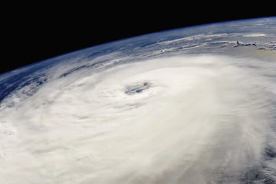
A depression formed on August 6 in the central Atlantic from a tropical wave. It moved westward and strengthened into TS Martha 12 hours later. Martha moved through the Windward Islands as a strengthening 60 mph tropical storm. It became a Cat. 1 hurricane and later a C2 hurricane in the eastern Caribbean. Martha made landfall in Haiti as a 110 mph Category 2 hurricane, causing lots of destruction. The storm weakened into a C1, but remained well organized. It restrengthened back into a Cat. 2 hurricane near the Bahamas, and later a C3 hurricane as it approached Florida. Martha made landfall south of Miami as a 120 mph Category 3 hurricane late on August 12, causing even more destruction. It remained a Cat. 3 as it crossed southern Florida, and the Gulf Coast was now looking at a monster hurricane threatening their coastline. Martha began to quickly intensify upon emerging into the Gulf, and became a C4 hurricane on the night of the 13th. It later strengthened into a Cat. 5, and peaked with winds of 175 mph and a pressure of 905 mbar. Martha turned sharply northward, and now the area from Louisiana to the Florida Panhandle was in serious trouble. It made landfall east of New Orleans, Louisiana at 2 p.m on August 15 as a strong C4 hurricane. Martha made landfall just a few days after Nathan made landfall. After making landfall, the storm produced a huge storm surge that caused catastrophic devastation between Louisiana and the Florida Panhandle. It quickly weakened over land, and dissipated on August 17 while in Kentucky. Its remnants reached the eastern seaboard. Martha caused massive devastation throughout its path, causing $90 billion in damage and killed 1,986 people. Most of the damage and deaths were in the U.S. The name Martha was later retired and replaced by Maggie for the 2107 season.
An area of disturbed weather formed on August 9 in the Gulf of Mexico. It quickly developed and became a depression on August 11. It soon became TS Nathan as it moved northward towards Louisiana. The storm gradually strengthened to its peak of 50 mph and 998 mbar before making landfall in eastern Louisiana on August 12. Nathan weakened over land before dissipating on August 13. The storm caused $84 million in damage and killed 4 people. Nathan made landfall only 3 days before the monster Hurricane Martha moved onshore in the same area.
The NHC began to monitor a tropical wave in the central Atlantic on August 14. It became a depression on August 16, and then TS Olly 12 hours later. It gradually strengthened as it moved westward. Olly became a hurricane on August 18 east of the Windward Islands. It then turned northward and moved away from the islands, later strengthening into a C2 on August 19. The hurricane became a C3 on August 20 and turned a little more northwestward. Olly reached its peak of 120 mph and 958 mbar southeast of Bermuda. It then weakened into a C2 east of Bermuda, and turned towards the northeast. Olly later weakened into a C1 and then a TS under increasing wind shear, before becoming extratropical on August 24. Olly didn't affect land.
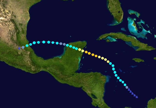
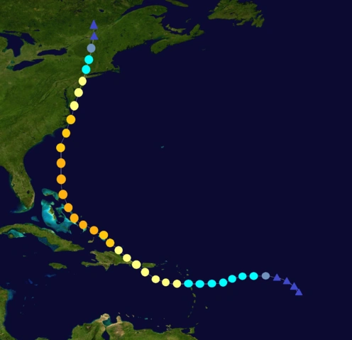
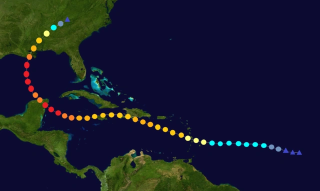
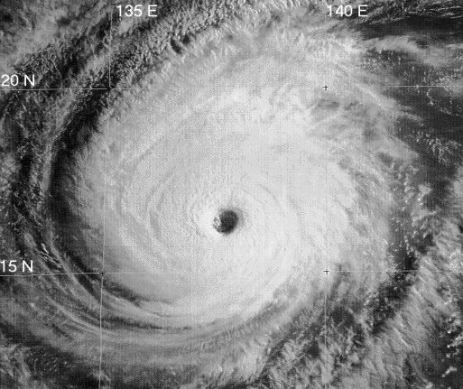
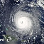
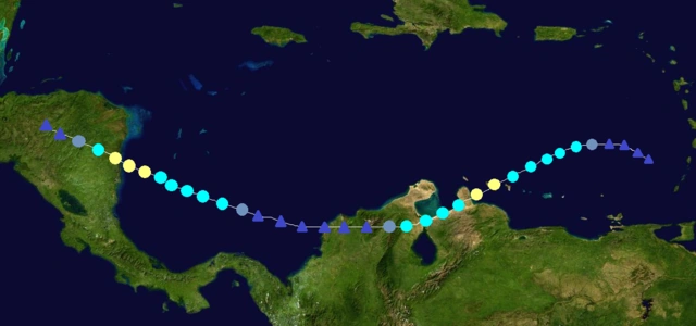
A depression formed in the central Atlantic on August 21 from a tropical wave. It became TS Phil the next morning. Phil became a C1 hurricane late on August 23 and crossed the Windward Islands at that strength. Continuing to strengthen, it became a C2 on August 24 and a C3 hurricane on August 25, before making landfall in Hispaniola as a 120 mph C3 on August 26. Phil weakened into a C2 over land, and turned westward and affected Jamaica and Cuba. After leaving Jamaica, Phil began to rapidly intensify, becoming a Cat. 5 early on August 29. The storm made landfall in the Yucatan with winds of 165 mph, causing massive devastation. It weakened into a C4 before emerging into the Gulf of Mexico. Once in the Gulf of Mexico, it quickly intensified into a Cat. 5 and reached its peak of 175 mph and 901 mbar. During this time, people along the Gulf Coast started a massive evacuation, and it became one of the largest evacuations in U.S. history. It made landfall in eastern Louisiana as a strong C4 hurricane, creating a similar storm surge to Martha's. It caused catastrophic devastation in the area, and it struck only a few weeks after Martha. After making landfall, it quickly weakened over land, and dissipated on September 1 while in Kentucky. Phil caused $83 billion in damage and killed 1,731 people, mostly in the U.S, the Yucatan, and Haiti. Due to it's catastrophic devastation and groundbreaking death toll, the name Phil was retired and replaced by Philip for the 2107 season.
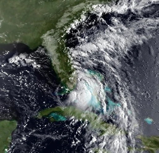
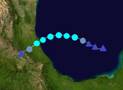
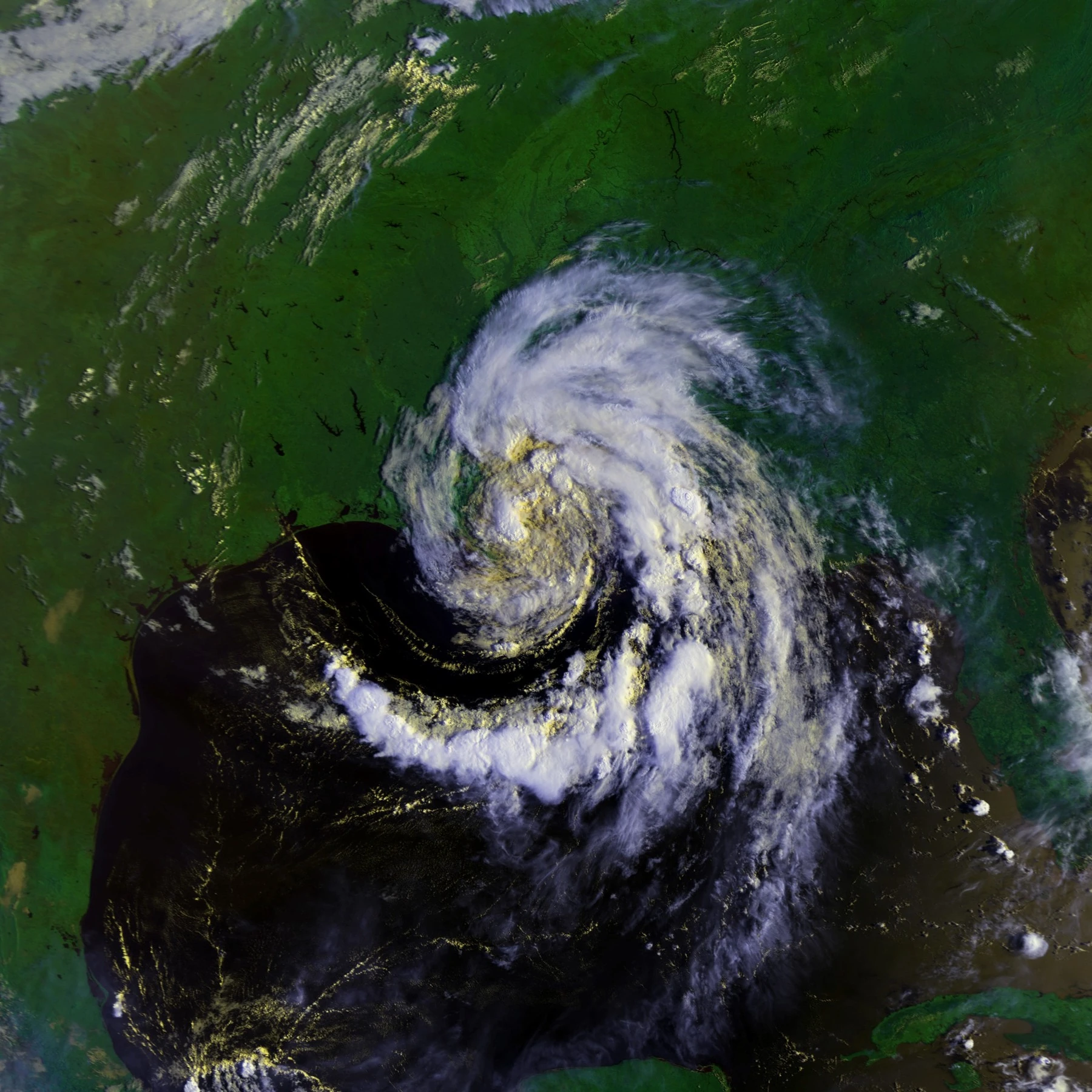
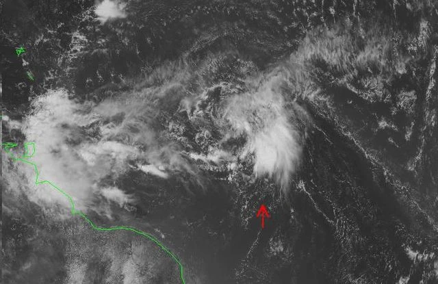
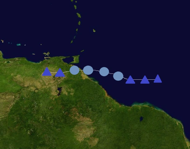
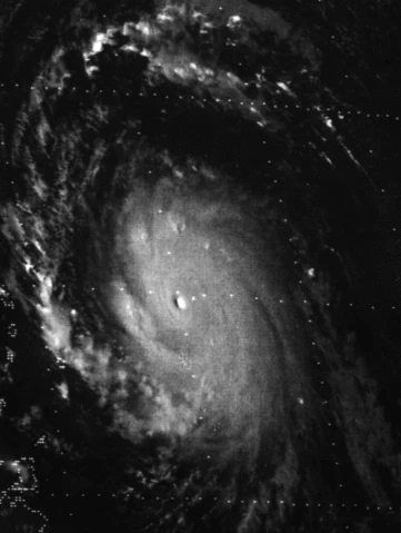
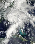
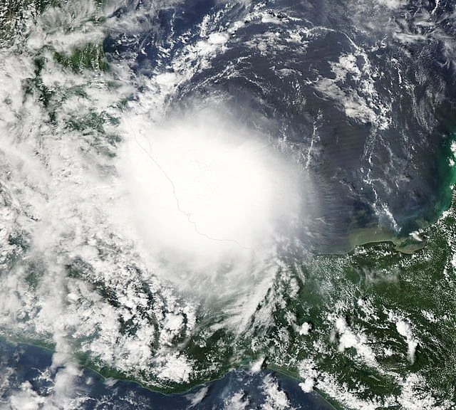
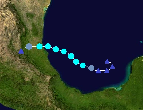
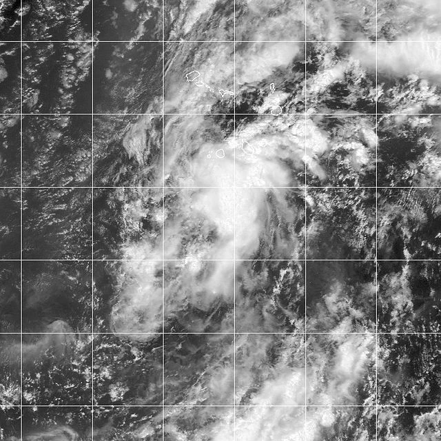
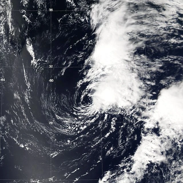
An area of disturbed weather formed north of Guyana on August 26. It quickly developed and became a depression the next day. The depression moved westward, and made landfall in eastern Venezuela on August 28. It dissipated over land later that day without ever becoming a tropical storm. TD 18 caused minimal damage.
NOTE: The depression is on the left side of the picture, near Venezuela.
A tropical wave moved off the coast of Africa on August 26. It quickly developed and became a depression on August 27 near Cape Verde. It later strengthened into TS Quincy as it moved westward. Quincy gradually strengthened, and became a hurricane early on August 30 after turning northward. It peaked with winds of 80 mph and a pressure of 984 mbar before weakening. The storm dissipated on September 1, while its remnants moved towards the Azores. Quincy caused lots of rain in the Cape Verdes but no damage or deaths.
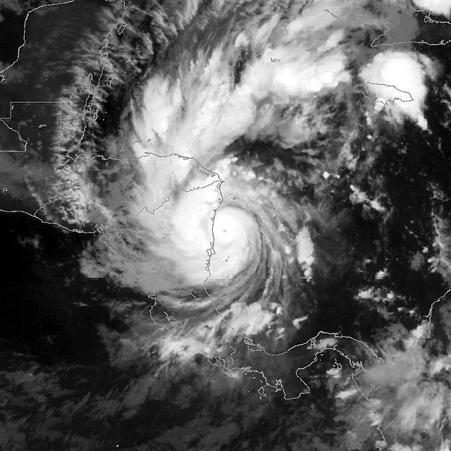
The NHC began to monitor an area of disturbed weather in the western Caribbean on August 29. The disturbed weather broke off from Hurricane Phil on August 28, as it raged through the western Caribbean. It gradually developed, and became a depression on August 31 east of Nicaragua and Honduras. It strengthened into a tropical storm 6 hours later. Rebecca continued to gradually strengthen and became a hurricane early on September 2. Strengthening was a little slower than it would have been, due to it moving over cooler waters that Phil upwelled. It quickly strengthened to its peak of 85 mph and 980 mbar before making landfall north of Belize that afternoon. Rebecca weakened over land and emerged into the Gulf of Mexico as a tropical storm. After emerging into the Gulf of Mexico, it restrengthened into a hurricane, and reached a secondary peak of 80 mph and 983 mbar before making landfall near Veracruz on September 4. It quickly weakened over land before dissipating early the next day. Rebecca caused $203 million in damage and killed 15.
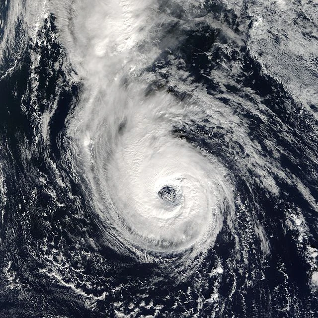
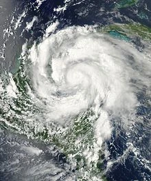
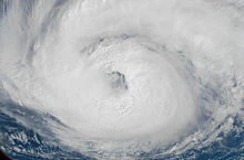
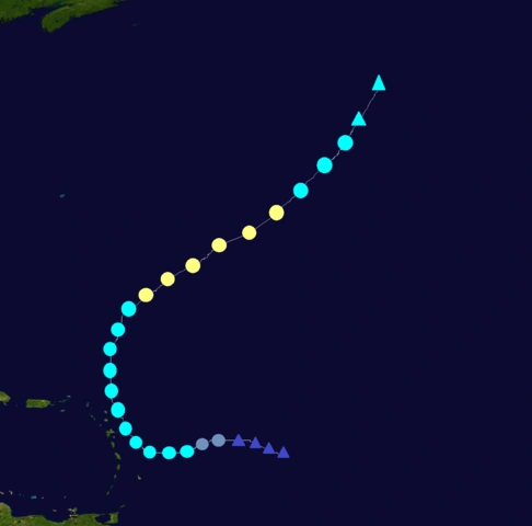
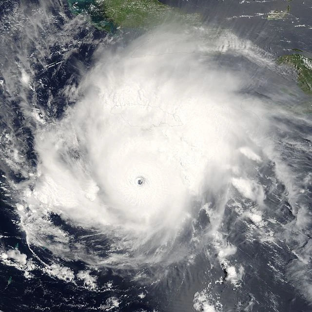
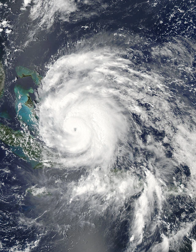
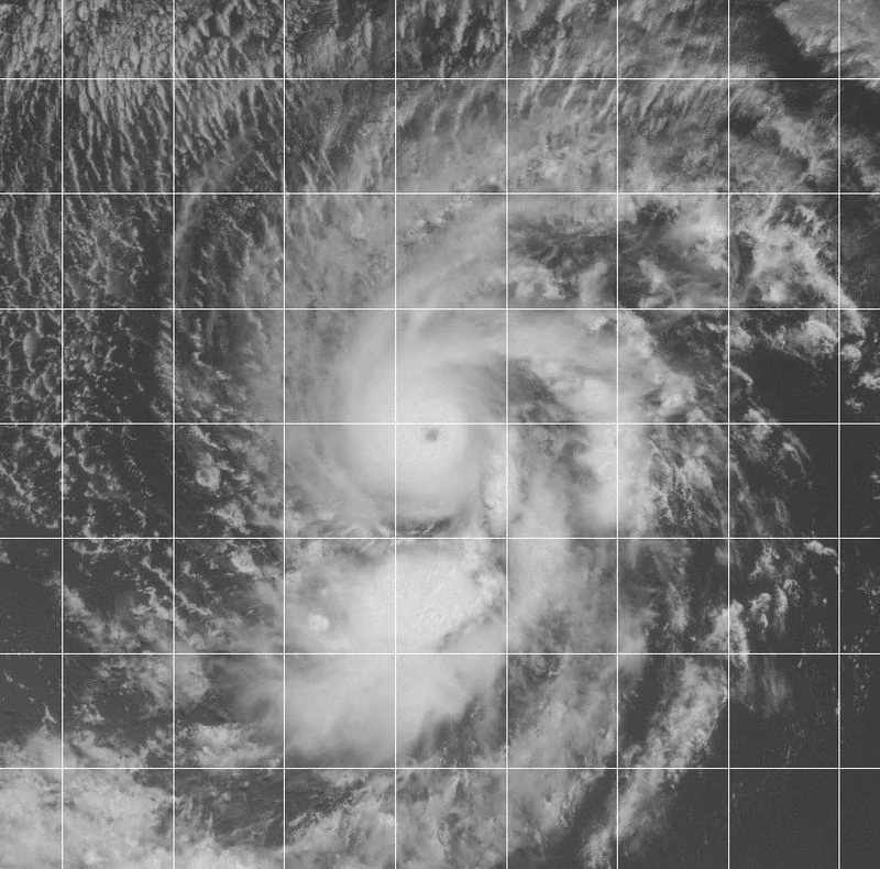
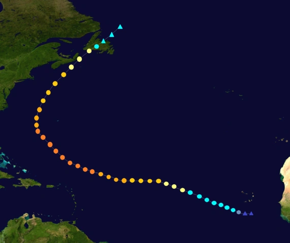
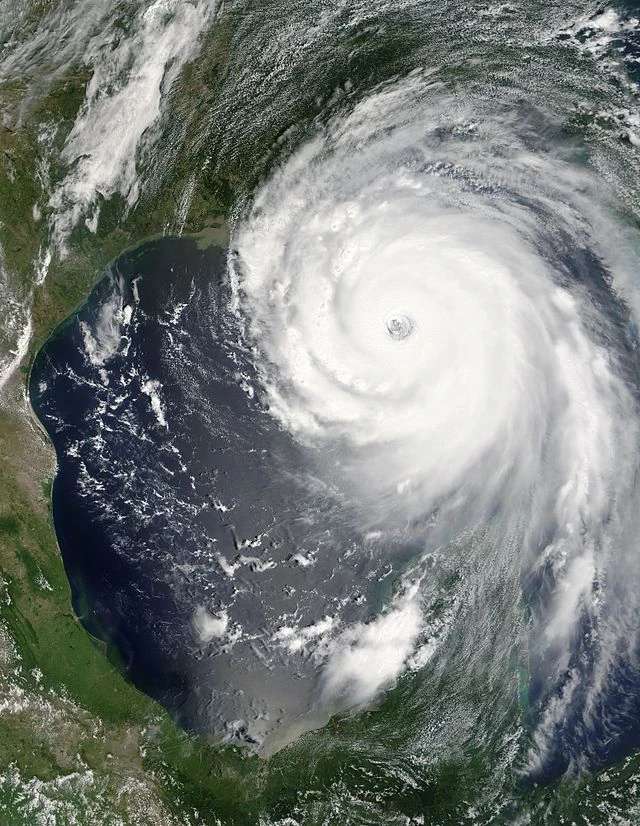
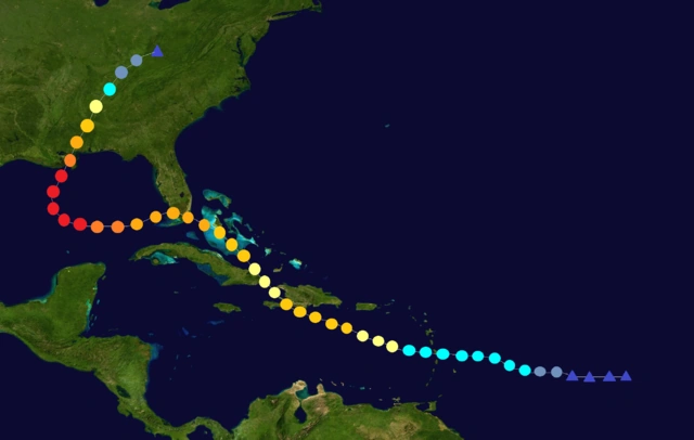
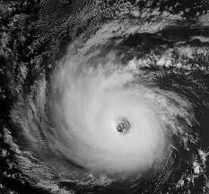
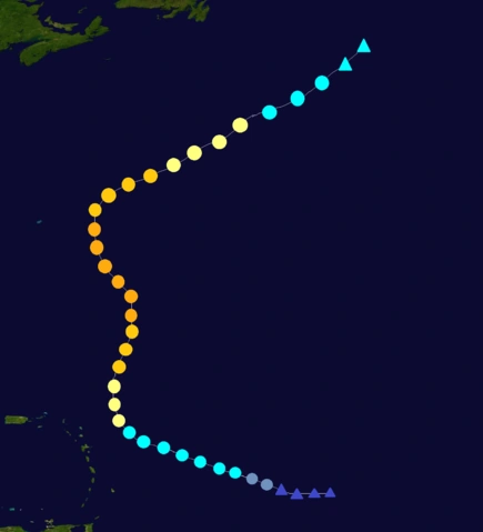
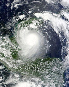
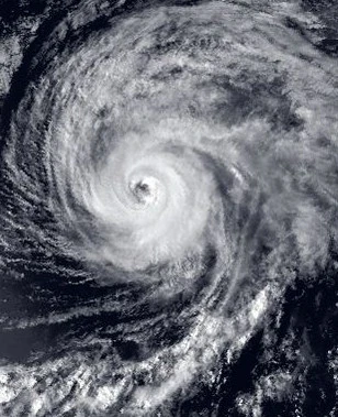
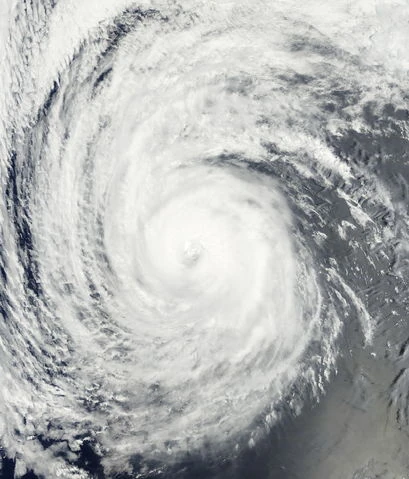
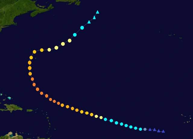
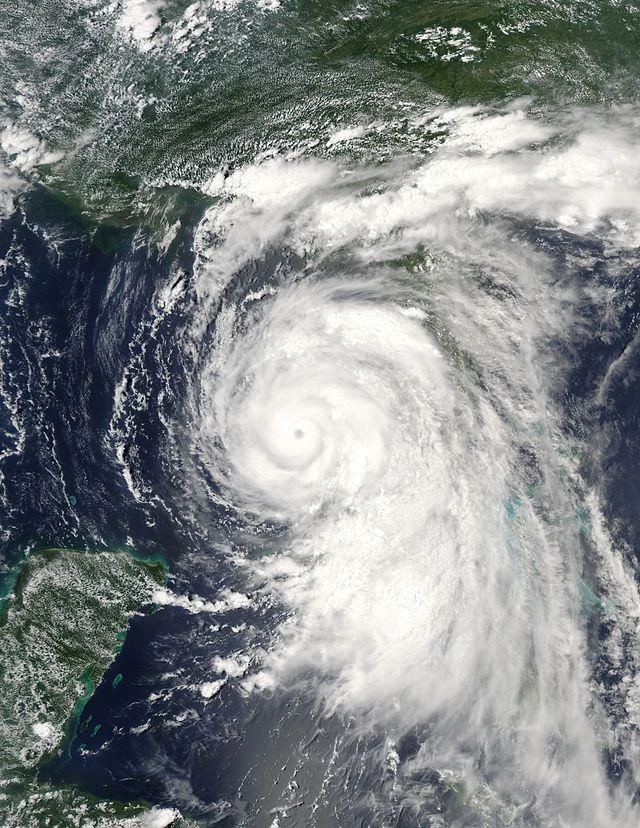
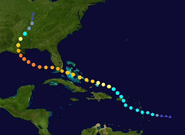
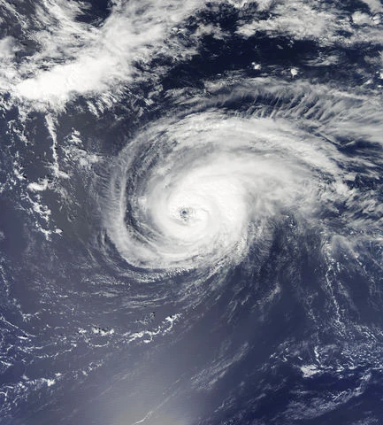
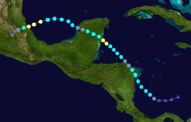
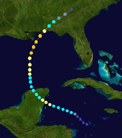
A tropical wave moved off the coast of Africa on September 2. It quickly developed into a depression the next day, and became Tropical Storm Steven 6 hours later near Cape Verde. Steven gradually strengthened as it moved across the Atlantic, and was already a Category 4 by the time it reached the Windward Islands on September 9. It strengthened into a C5 just after crossing the islands, and then struck Puerto Rico and Hispaniola at that intensity, causing mass destruction. It weakened into a C4 as it crossed Haiti, but later strengthened into a C5 and struck Jamaica at that strength, causing even more devastation. After leaving Jamaica, Steven quickly strengthened into a rare Category 6 hurricane and then struck Honduras with winds of 205 mph, causing extremely catastrophic devastation and more than 20,000 deaths. It quickly weakened over land and emerged into the Pacific as a Category 2 on September 16. The storm strengthened back into a C4 and turned north, making landfall in southern Mexico as a C4. It weakened into a C3 as it crossed into the Bay of Campeche, and after emerging into the Gulf of Mexico, Steven started to strengthen again. It rapidly intensified back into a C6, and reached its peak of 215 mph and 859 mbar before making landfall in Louisiana at that intensity, causing a storm surge that was much higher than Katrina's (2005), and extremely massive devastation. It then turned eastward back into the Gulf, and made landfall in northern Florida as a 210 mph monster, causing even more devastation. Steven then emerged into the Atlantic as a C5 and then turned towards the East Coast. It made landfall on the outer banks of North Carolina as a C5, and then weakened into a C4 as it followed the coast. Steven began to rapidly weaken as it moved further inland through New England, and finally dissipated on September 25 while entering Canada. Steven caused EXTREMELY MASSIVE DEVASTATION of $405 billion dollars in damage and 41,524 deaths throughout its path, becoming one of the most devastating hurricanes in history. This storm will never be forgotten. It was later retired and replaced by Stein for the 2107 season.
An extratropical cyclone southwest of the Azores was monitored by the NHC on September 5. It quickly developed subtropical characteristics and was declared a subtropical depression on September 6. It later strengthened into Subtropical Storm Tammy, and continued to slowly strengthen as it passed through the Azores. Tammy became tropical early on September 8, and continued to strengthen to its peak of 65 mph and 989 mbar as it moved northward. The storm then turned westward and did a cyclonic loop before dissipating on September 10 under cold waters. Tammy caused minimal damage to the Azores.
A tropical wave in the central Atlantic became a depression on September 9. It later strengthened into a tropical storm and was named Utor. The storm continued to strengthen as it moved westward, and became a hurricane on September 11 while turning northwestward. Utor soon became a Category 2 and reached its peak of 105 mph and 975 mbar as it moved northward. It started to weaken after that and turned towards the northeast. The storm dissipated on September 15. Utor didn't affect land.
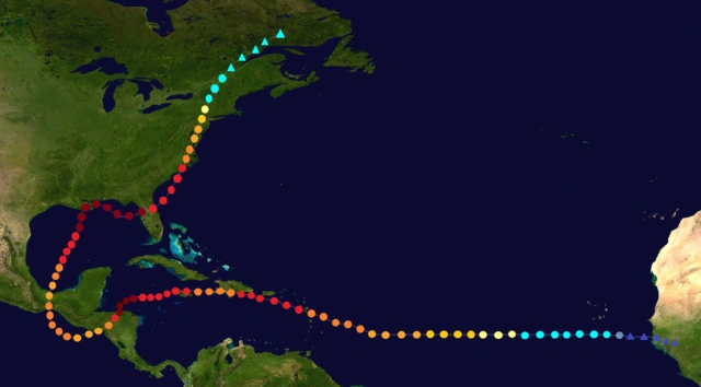
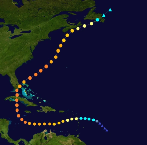
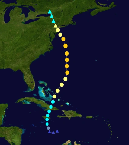
The NHC began to monitor a tropical wave east of the Windward Islands on September 9. It gradually developed and became a depression on September 11. It strengthened into TS Vick 6 hours later. Vick quickly strengthened and became a hurricane late on September 12 while crossing the Windward Islands. The storm continued to strengthen and became a C2 on September 13 and a C3 on September 14. While becoming a Cat. 3, the storm's outer rainbands affected Venezuela. Vick became a Category 4 on September 15 and later turned northward. It reached its peak of 150 mph and 940 mbar before making landfall in Cuba late on September 16 with winds of 145 mph. Vick continued northward and made landfall near Miami, Florida on September 17, before turning northeastward and briefly weakening into a C3 due to land interaction. It strengthened back into a C4 as it moved into the open Atlantic, and soon reached a secondary peak of 140 mph and 948 mbar. The storm later weakened back into a C3 and turned more northward and threatened Atlantic Canada. Vick passed very close to Nova Scotia as a Cat. 2 before turning more eastward and avoiding landfall in the area. It weakened into a C1 and made landfall in Newfoundland as a tropical storm, before dissipating on September 21. Vick caused $10.3 billion dollars in damage and killed 146 people. The name was later retired and was replaced by Vidal for the 2107 season.
A tropical wave moved off the west coast of Africa late on September 13. It became a depression the next day, and then a tropical storm 6 hours later near Cape Verde. Whitney continued to strengthen as it moved westward, and became a hurricane on September 16. It then became a Cat. 2 late on September 17, a Cat. 3 on September 18, a Cat. 4 on September 19, and finally a Cat. 5 on September 20 while near the Lesser Antilles. Whitney continued to strengthen to its peak of 175 mph and 911 mbar late on September 21, before weakening as it approached the U.S. east coast due to an eyewall replacement cycle. It made landfall in North Carolina at 2 p.m. on September 23 as a 140 mph Category 4 hurricane. Whitney turned to follow the east coast, and quickly weakened over land. It dissipated on September 25 while entering Vermont. Whitney caused $17.6 billion in damage and killed 78 people. The name Whitney was later retired and replaced by Waverly for the 2107 season.
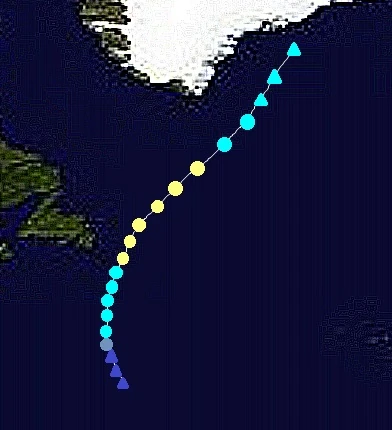
An area of disturbed weather became a depression on September 15 in the far north Atlantic. It later became Tropical Storm Xina, and continued to strengthen despite its high latitude. Xina became an unusual high-latitude hurricane early on September 17 east of Newfoundland, and then strengthened to its peak of 80 mph and 980 mbar. Cold waters began affecting Xina, weakening it to a tropical storm and causing it to dissipate on September 19 southeast of the southern tip of Greenland. Xina caused minimal damage.
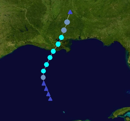
An area of disturbed weather formed on September 18 in the western Caribbean. It later became a depression on September 20 in the southern Gulf of Mexico. It became Tropical Storm York 6 hours later. Continuing to strengthen, York reached hurricane status early on the 22nd, and soon reached its peak of 80 mph and 986 mbar. The storm made landfall in northwestern Florida early on September 23 with winds of 75 mph. After that, York weakened and dissipated on September 24 while entering South Carolina. York caused $452 million in damage and 16 deaths.
A tropical wave in the central Caribbean became a depression on September 24. It later strengthened into TS Zelda as it moved northward. Zelda soon made landfall in Jamaica with 50 mph winds and Cuba with 60 mph winds. After leaving Cuba, Zelda strengthened into a hurricane while in the Bahamas. It then reached Cat. 2 intensity and reached its peak of 105 mph and 969 mbar. After that, it weakened into a Cat. 1 while approaching the U.S east coast and growing larger. Zelda made landfall in New Jersey as a C1 hurricane and became extratropical shortly afterwards early on September 29. Zelda caused $1.6 billion in damage and killed 88 people. Despite the damage, the name wasn't retired.
The NHC began to monitor a tropical wave near the Cape Verde Islands on September 25. It slowly developed as it moved westward, and became a depression on September 28 while in the central Atlantic. It strengthened into TS Andrew 6 hours later. Andrew gradually strengthened as it moved westward under favorable conditions, and the NHC soon predicted a major hurricane. It became a hurricane late on September 30 and a Cat. 2 on October 1. Andrew then became a Cat. 3 major early on October 2 and a Cat. 4 early on October 3. It then reached its peak intensity of 150 mph and 938 mbar on the morning of October 4, and soon threatened Bermuda as it turned more northward. Andrew later weakened into a C3 as Bermuda prepared for the storm. It then passed very close to Bermuda as a Cat. 2 hurricane late on October 5 and turned eastward. It continued to weaken under unfavorable conditions and dissipated early on October 8. Andrew caused $90 million in damage and 2 deaths to Bermuda.
An area of disturbed weather formed on September 26 near Nicaragua. It later made landfall in the northern part of the country, bringing heavy rain and landslides that killed 32 people. After leaving Nicaragua and Honduras, it became a depression on September 29 while in the western Caribbean. The depression soon strengthened into TS Beryl and continued to strengthen as it approached the Yucatan. Beryl made landfall on the eastern coast of the Yucatan early on October 1 with winds of 60 mph. After leaving the Yucatan, it strengthened to its peak of 70 mph and 988 mbar on October 2 (almost becoming a hurricane), before wind shear weakened it slightly as it approached Florida. Beryl made landfall south of Tampa, Florida with winds of 60 mph early on October 3. It weakened into a depression over land before briefly emerging into the Atlantic that night. It made another landfall in southeastern Georgia the next morning, and dissipated over land. Beryl caused $185 million in damage and killed 46 people throughout its path.
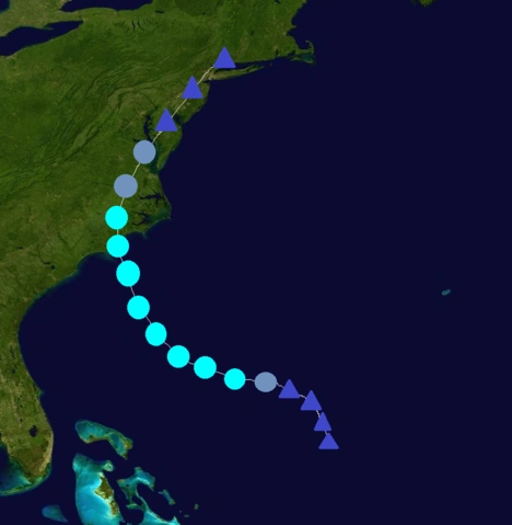
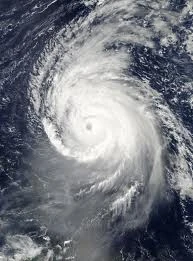
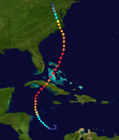
A strong tropical wave in the southwestern Caribbean became a depression on October 4. It later strengthened into TS Charley, and continued to strengthen under SSTs of 86 F and low wind shear. Charley became a hurricane on October 6 as it moved northward. After that, the SSTs warmed to 91 F and the storm began to rapidly intensify, becoming a Cat. 5 only 36 hours later. Charley continued to strengthen to its peak of 170 mph and 906 mbar before making landfall in Cuba with 165 mph winds, causing lots of devastation. It weakened into a C4 over land but later strengthened back into a C5 while entering the Bahamas. The storm reached a secondary peak of 165 mph and 910 mbar as it moved through the Bahamas. It then weakened into a C4 as it approached the U.S. east coast due to an eyewall replacement cycle, and weakened even further to a C3 as it was about to make landfall. Charley made landfall in North Carolina at 8 p.m. on October 12 with winds of 120 mph, causing lots of destruction. It quickly weakened over land before dissipating early on October 14 while in northern Virginia. Charley caused $28.4 billion dollars in damage and killed 60 people throughout its path. The name Charley was later retired and replaced by Chris for 2107.
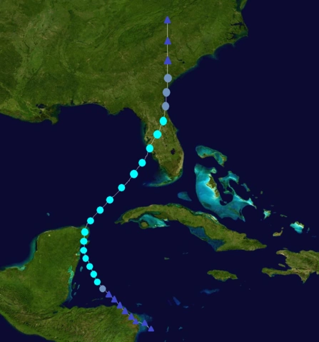
A tropical wave east of the Windward Islands became a depression on October 8. It strengthened into TS Diana 6 hours later, and then crossed the Windward Islands on October 9 with 45 mph winds. After that, Diana reached Puerto Rico on October 10 with 60 mph winds, and continued to strengthen after leaving Puerto Rico. It became a hurricane on October 11 and a Cat. 2 early on October 12 as it approached the Bahamas. The storm passed through the Bahamas as a Category 2 hurricane, before strengthening into a C3 near Florida landfall. Diana made landfall on the southern tip of Florida on October 13 with 120 mph winds. It remained a Category 3 as it emerged into the Gulf of Mexico. After that, Diana quickly strengthened into a Cat. 4 and reached its peak of 155 mph and 930 mbar (almost becoming a Category 5). It made landfall in Louisiana on October 15 with 145 mph winds. The storm quickly weakened over land before dissipating on October 17 while in Kentucky. Diana caused $20.4 billion dollars in damage and killed 106 people throughout its path. The name was later retired and replaced by Danielle for 2107.
The NHC began to monitor an area of disturbed weather in the Bay of Campeche on October 8. It quickly organized and became a depression on October 10. The depression strengthened into Tropical Storm Ernesto after that. Ernesto moved westward and reached its peak of 60 mph and 994 mbar before making landfall north of Veracruz, Mexico on October 12. It quickly weakened over land before dissipating later that day. Ernesto caused $45 million in damage and killed 4 people.
A tropical wave in the central Caribbean became better organized and was declared a depression on October 14 while south of Haiti. It later strengthened into TS Frances, and continued to strengthen as it moved westward. Frances made landfall in Jamaica on October 15 with 50 mph winds. It then turned northward and made landfall in Cuba that night with winds of 60 mph. Frances weakened somewhat over land, but remained well organized. After leaving Cuba, it passed through the Bahamas and later strengthened into a hurricane. Continuing northeastward, it became a Category 2 and reached its peak of 105 mph and 972 mbar on October 18 while close to Bermuda. Frances turned westward after that and weakened into a C1 hurricane. The storm later weakened into a TS as it turned northeastward again and dissipated on October 20 hundreds of miles south of Newfoundland. Frances caused $426 million in damage and killed 43 people throughout its path. The name wasn't retired.
A tropical wave in the central Atlantic was monitored by the NHC from October 16 to October 18. It quickly organized despite strong wind shear and became a depression on October 19. It moved northwestward without strengthening and dissipated on October 20 due to the wind shear. TD 35 didn't affect land.
An extratropical cyclone existed in the eastern Atlantic on October 23. It became a subtropical depression the next day. The subtropical depression made a cyclonic loop and strengthened into Subtropical Storm Georges. Georges moved quickly eastward and became tropical on October 26. It then became a hurricane early on October 27 (in an unusual spot since it was approaching Portugal). The storm reached its peak of 80 mph and 990 mbar before making landfall near Lisbon, Portugal as a 60 mph TS early on October 28. It rapidly degenerated over land before dissipating later that day. It was one of very few landfalls in Portugal since records began. Georges caused $118 million in damage and killed 13 people.
An area of disturbed weather in the southwestern Caribbean became a depression on October 29. It later strengthened into TS Hortense, and continued to gradually strengthen as it approached the Nicaragua/Honduras area. It made landfall in northeastern Nicaragua late on October 30 with 60 mph winds. Hortense weakened into a depression over land, but after emerging into the northwest Caribbean, started to strengthen again. It became a hurricane and reached an intensity of 75 mph and 986 mbar before making landfall in northern Belize early on November 2. Hortense quickly weakened over the Yucatan and emerged into the Gulf of Mexico as a depression. It started to strengthen again, eventually restrengthening into a hurricane and reaching its lowest pressure of 984 mbar (with 75 mph winds) before making landfall near Veracruz, Mexico on November 5. The storm quickly weakened over the mountains of Mexico before dissipating on November 6. Hortense caused $314 million in damage and killed 46 people.
The NHC began to monitor a tropical wave in the western Caribbean on November 6. It gradually developed and became a depression on November 8. The depression became TS Ivan 6 hours later. Ivan moved westward and strengthened into a hurricane before making landfall on the Yucatan Peninsula on November 10 with 80 mph winds. It turned northward and weakened into a tropical storm over land, but remained well organized. It started to strengthen again after emerging into the Gulf of Mexico, where it became a hurricane and then a C2 hurricane under favorable conditions. Ivan reached its peak of 110 mph and 968 mbar before making landfall near Mobile, Alabama as a 90 mph C1. The storm rapidly weakened over land before dissipating on November 15 while entering Georgia. The remnants of Ivan contributed to the formation of a massive nor-easter that hit the east coast. Ivan caused $1.3 billion in damage and killed 38 people. The name wasn't retired.
A tropical wave in the eastern Caribbean became better organized and became a depression on November 11. It later strengthened into TS Joan, and continued to strengthen as it moved southwestward. It then became a hurricane before making an unusual landfall in western Venezuela on November 13. Joan weakened over land before dissipating on November 14 while entering Colombia. Its remnants were monitored for possible regeneration as it was expected to enter the southwestern Caribbean. After emerging into the Caribbean, its remnants got better organized, and it redeveloped into a depression on November 16. Joan later strengthened into a tropical storm and continued to strengthen as it moved towards Nicaragua. It became a hurricane and reached its peak of 80 mph and 981 mbar before making landfall in Nicaragua on November 18. Joan rapidly weakened over land before dissipating early the next day. Joan caused $120 million dollars in damage and 34 deaths throughout its path.
An area of disturbed weather formed on November 25 southwest of Bermuda. It later became a depression and then became TS Klaus while very close to Bermuda. Klaus gradually strengthened as it moved northeastward, and became a hurricane early on November 28. It then reached its peak of 85 mph and 980 mbar before weakening. Klaus became extratropical on November 29. Klaus caused minimal damage.
An extratropical cyclone northeast of the Lesser Antilles became a subtropical depression on December 19, a few days after the official end of the season. It later became STS Lili, and eventually became tropical as it moved northward. Lili turned eastward and did a cyclonic loop as it reached its peak intensity of 65 mph and 990 mbar. The storm then turned back to the north and started to weaken after that, and dissipated on Christmas Eve. Lili didn't affect land.
Storm names[]
The following names were used to name tropical cyclones this year. This is the same list used in the 2095 season, expect for Fernando, Luke, and Olly, which replaced Fern, Luther, and Olympia. The names Fernando, Luke, Olly, Quincy, Utor, Xina, York, and Zelda were used in the Atlantic for the first time this year. Unused names are marked in gray.
Alice
Bobby
Cassie
Dylan
Elizabeth
Fernando
Gillian
Henry
Ira
Josh
Kim
Luke
Martha
Nathan
Olly
Phil
Quincy
Rebecca
Steven
Tammy
Utor
Vick
Whitney
Xina
York
Zelda
Secondary naming list[]
Since this season exhausted the first list, a second list was used to name storms that would have formed after Zelda. This list consists of names that have been retired before the year 2050 (especially names that were retired before 2020). These names were brought back because they were retired over 50 years ago and many people would have forgot about the devastating storms that happened before 2050. Just like the primary list, the secondary list will reappear after 6 years. This was the first time that a secondary list was used to name storms had the season exhausted the first list. In previous seasons, the Greek Alphabet was used instead. But the Greek Alphabet would have still been used if this season was hyperactive enough to exhaust even the secondary list.
Andrew
Beryl
Charley
Diana
Ernesto
Frances
Georges
Hortense
Ivan
Joan
Klaus
Lili
Mitch (unused)
Nana (unused)
Oscar (unused)
Paloma (unused)
Richard (unused)
Sally (unused)
Tomas (unused)
Valerie (unused)
Wilfred (unused)
Retirement[]
Due to extensive damage and deaths, the names Gillian, Josh, Martha, Phil, Steven, Vick, Whitney, Charley, and Diana were officially retired, and will never be used again for an Atlantic hurricane. They were replaced by Gitanna, Jackson, Maggie, Philip, Stein, Vidal, Waverly, Chris, and Danielle.
Primary list for 2107:
Alice
Bobby
Cassie
Dylan
Elizabeth
Fernando
Gitanna
Henry
Ira
Jackson
Kim
Luke
Maggie
Nathan
Olly
Philip
Quincy
Rebecca
Stein
Tammy
Utor
Vidal
Waverly
Xina
York
Zelda
Secondary list for 2107:
Andrew
Beryl
Chris
Danielle
Ernesto
Frances
Georges
Hortense
Ivan
Joan
Klaus
Lili
Mitch
Nana
Oscar
Paloma
Richard
Sally
Tomas
Valerie
Wilfred
Season effects[]
This is a table of the storms and their effects in the 2101 Atlantic hurricane season. This table includes the storm's names, duration, peak intensity, Areas affected, damages, and death totals. Damage and deaths include totals while the storm was extratropical, a wave or a low. All of the damage figures are in 2101 USD (the listed damage figure is in millions).
Windward Islands, Lesser Antilles, Puerto Rico, Hispaniola, The Bahamas, US East Coast
12,800
58
Kim
July 28 – July 30
Tropical storm
50 (85)
997
Mexico
Minimal
1
Luke
August 4 – August 14
Category 4 hurricane
150 (240)
934
Cape Verde, Nova Scotia, Newfoundland
156
14
Martha
August 6 – August 17
Category 5 hurricane
175 (280)
905
Windward Islands, Hispaniola, Cuba, The Bahamas, Florida, US Gulf Coast
90,000
1,986
Nathan
August 11 – August 13
Tropical storm
50 (85)
998
Louisiana, Mississippi
84
4
Olly
August 16 – August 24
Category 3 hurricane
120 (195)
958
None
None
0
Phil
August 21 – September 1
Category 5 hurricane
175 (280)
901
Windward Islands, Lesser Antilles, Puerto Rico, Hispaniola, Cuba, Jamaica, Yucatan Peninsula, US Gulf Coast
83,000
1,731
Eighteen
August 27 – August 28
Tropical depression
35 (55)
1001
Guyana, Venezuela
Minimal
0
Quincy
August 27 – September 1
Category 1 hurricane
80 (130)
984
Cape Verde
None
0
Rebecca
August 31 – September 5
Category 1 hurricane
85 (140)
980
Belize, Yucatan Peninsula, Mexico
203
15
Steven
September 3 – September 25
Category 5 hurricane
215 (345)
859
Windward Islands, Lesser Antilles, Puerto Rico, Hispaniola, Cuba, Jamaica, Honduras, Nicaragua, El Salvador, Guatemala, Mexico, US Gulf Coast, Florida, US East Coast
405,000
41,524
Tammy
September 6 – September 10
Tropical storm
65 (100)
989
Azores
Minimal
0
Utor
September 9 – September 15
Category 2 hurricane
105 (165)
975
None
None
0
Vick
September 11 – September 21
Category 4 hurricane
150 (240)
940
Windward Islands, Venezuela, Colombia, Jamaica, Cuba, Florida, The Bahamas, Nova Scotia, Newfoundland
10,300
146
Whitney
September 14 – September 25
Category 5 hurricane
175 (280)
911
Cape Verde, Lesser Antilles, The Carolinas, US East Coast
17,600
78
Xina
September 15 – September 19
Category 1 hurricane
80 (130)
980
Newfoundland, Greenland
Minimal
0
York
September 20 – September 24
Category 1 hurricane
80 (130)
986
Cuba, Yucatan Peninsula, Florida, Georgia
452
16
Zelda
September 24 – September 29
Category 2 hurricane
105 (165)
969
Jamaica, Cuba, The Bahamas, US East Coast
1,600
88
Andrew
September 28 – October 8
Category 4 hurricane
150 (240)
938
Bermuda
90
2
Beryl
September 29 – October 4
Tropical storm
70 (110)
988
Nicaragua, Honduras, Yucatan Peninsula, Cuba, Florida, Georgia, South Carolina
185
46
Charley
October 4 – October 14
Category 5 hurricane
170 (270)
906
Nicaragua, Honduras, Cuba, Florida, The Bahamas, US East Coast
28,400
60
Diana
October 8 – October 17
Category 4 hurricane
155 (250)
930
Windward Islands, Lesser Antilles, Puerto Rico, Hispaniola, Turks & Caicos Islands, The Bahamas, Cuba, Florida, US Gulf Coast
20,400
106
Ernesto
October 10 – October 12
Tropical storm
60 (95)
994
Mexico
45
4
Frances
October 14 – October 20
Category 2 hurricane
105 (165)
972
Haiti, Jamaica, Cuba, The Bahamas, Turks & Caicos Islands, Bermuda