| First storm formed | March 23, 2018 |
| Last storm dissipated | September 15, 2018 |
| Strongest storm | Gabriel - 140 mph; 937 mbar |
| Total depressions | 7 (1 subtropical) |
| Total storms | 7 (1 subtropical) |
| Hurricanes | 3 |
| Major hurricanes | 2 |
| Total damages | >$8.8 billion (2018 USD) |
| Total fatalities | 51 |
The 2018 Lake Superior hurricane season was a very inactive tropical cyclone event that started on May 1, 2018 and ended on December 15, 2018. The season was the third season to have named storms over Lake Superior, with the first being the 2016 Lake Superior hurricane season. The first official system of the season, Tropical Storm Alan, formed on March 23. The season was the most inactive on record, with only 7 named storms. Only 3 hurricanes were recorded during the seasons and two majors. The two majors were the most destructive, with Daphne causing $4.8 billion in damages. The last storm of the season, which was also the last major, Gabriel, caused $1 billion in damages. The season officially started with Alan, although two storms from the 2017 season were active at the New Year, Willow and Adrian. Adrian struck Isle Royale and caused $2.5 billion in damages. It was retired before the retired names of this season were announced. Bertha was the second storm of the season, after Alan. It struck the Keweenaw Peninsula, causing $150 million in damages. Caleb was the only subtropical storm of the season, moving along the Ontarian Coast. Tropical Storm Elmer traversed the northwestern corner of the basin, causing minimal damage along its path, followed by the longest lasting hurricane on record in the basin, Frances. The season was relatively calm overall, as it was one of the least costly and least deadliest seasons on record.
Seasonal predictions
| Source | Date | Named Storms | Hurricanes | Major Hurricanes |
|---|---|---|---|---|
| TGMC | October 16, 2017 | 7-9 | 2 | 0-1 |
| DHC | October 17, 2017 | 4-8 | 3 | 1 |
| TGMC (revised) | December 29, 2017 | 12-14 | 5-6 | 3-5 |
| DHC (revised) | January 1, 2018 | 27-28 | 10-14 | 6-8 |
| TGMC (revised) | March 22, 2018 | 29-33 | 15-18 | 9-13 |
| DHC (revised) | March 31, 2018 | 40 | 19 | 10 |
| TGMC (revised) | May 5, 2018 | 18-20 | 8-10 | 4-6 |
| TGMC (revised) | May 11, 2018 | 10-12 | 4-6 | 0-2 |
| SDTWFC | May 11, 2018 | 12-15 | 4-8 | 2-4 |
| FRMC | May 15, 2018 | 10-11 | 3-5 | 1-2 |
| DHC (revised) | May 31, 2018 | 9 | 2 | 0 |
| TGMC (revised) | July 8, 2018 | 12-14 | 5-7 | 2-4 |
| DHC (revised) | July 30, 2018 | 13 | 5 | 2 |
On October 16, 2017, TGMC announced their first seasonal forecast, predicting only 7-9 named storms. This also included detailed information on the expected up-welled waters caused by the 2017 season, leading to cold water. Only two hurricanes were predicted and 0-1 major hurricanes were predicted. The Douglas Hurricane Center (DHC) submitted their first ever prediction of a Lake Superior hurricane season, predicting 4-8 named storms, 3 hurricanes, and 1 major hurricane. This was due to the same explanations that TGMC had explained. On December 29, 2017, after much analyzing data, TGMC noticed that the cold winter will give a break for the upwelled waters, letting the waters warm back to normal temperature by May 2018, allowing a slightly above average season to occur. DHC revised their prediction too, on New Year's Day 2018, after analyzing temperature increasing over the Main Development Region near Duluth, Minnesota, which noted that the waters could spin up 4-5 storms before May, but none will reach over hurricane strength. DHC noted that there would be a significant increase in named storms, hurricanes, and major hurricanes. They noted that the season could have the most major hurricanes since 2016. TGMC revised their prediction on March 22, 2018, noting that the season would be a hyperactive season and become the most active season on record in the Northern Hemisphere on record, possibly reaching 33 named storms. DHC also revised their prediction, saying that 40 named storms will form, corresponding to the revised prediction released by TGMC. As conditions began to become less favorable for major development, TGMC revised their forecast prediction to only 18-20 named storms, 8-10 hurricanes, and 4-6 majors, with a possibility of a major hurricane landfall in the month of May. After extreme weakening of the SSTs in the Lake Superior basin, TGMC revised their prediction yet again on May 11, stating that 10-12 named storms would form, 4-6 hurricanes would occur, and 0-2 majors would be likely to occur.
On May 11, the SDTWFC released their prediction of 12-15 storms, 4-8 hurricanes, and 2-4 major hurricanes for the whole year. On May 31, DHC once again revised their forecast down to 9 named storms, 2 hurricanes, and 0 major hurricanes. On July 8, after the beginning of a transition to a season with more conducive conditions for activity, TGMC revised their forecast up to 12-14 named storms, 5-7 hurricanes, and 2-4 majors, similar their December 29, 2017 forecast. On July 30, DHC revised their prediction to 13 named storms, 5 hurricanes, and 2 major hurricanes, to follow TGMC's forecast.
Storms

Tropical Storm Alan
| Tropical storm (SSHWS) | |||
|---|---|---|---|
| |||
| Duration | March 23 – March 25 | ||
| Peak intensity | 40 mph (65 km/h) (1-min) 999 mbar (hPa) | ||

On March 21, a tropical wave formed near Duluth, Michigan, after a warm-up of waters from a recent blizzard. The tropical wave had subtropical characteristics at first, with some believing that it could have been influenced by the precursor of Winter Storm Toby. Others believe that moisture from what would become Tropical Storm Boris in Lake Lanier could have influenced the origins of the storm. On March 22, the tropical wave was invested as Invest 91S, after Invest 90s occurred in January, when a possible subtropical storm could have became a fully-fledged subtropical cyclone. On March 23, the tropical wave was designated as Tropical Depression 01S, after a closed circulation was found in the system. Although the GLHC at first called it Subtropical Depression 01S, the storm developed all tropical characteristics. This let the GLHC designate it as a tropical depression instead of a subtropical depression. Overnight on March 23, the storm made landfall in the Apostle Islands, causing minimal damage and no fatalities. Early in the morning on March 24, 01S became Tropical Storm Alan, with winds of 40 mph while it was about to make landfall on Madeline Island, Wisconsin. However, vertical wind shear exceeding 40 knots caused Alan to dissipate on March 25.
Tropical Storm Bertha
| Tropical storm (SSHWS) | |||
|---|---|---|---|
| |||
| Duration | May 5 – May 7 | ||
| Peak intensity | 60 mph (95 km/h) (1-min) 996 mbar (hPa) | ||

On May 1, a tropical wave began to slowly move off of the coast of Duluth. The tropical wave then began to strengthen as it neared the Apostle Islands, causing minor to moderate flooding at some of the gauges in the area. On May 2, the tropical wave weakened some as it then moved into the stretch between the Keweenaw Peninsula and the Apostle Islands. On May 3, the storm was designated as Potential Tropical Cyclone 02S, as tropical storm watches and warnings were posted for parts of Houghton and Keweenaw Counties in the Keweenaw Peninsula, with the potential of a high-end tropical storm landfall in the region. On May 4, the tropical wave began to strengthen some more, as it was nearing 20 miles until landfall. Finally, on the morning of May 5, Tropical Storm Bertha formed, just as it was about to make landfall in Houghton County. As it was right on the coast of the peninsula, Bertha strengthened into a 60 mph tropical storm, causing wind damage and flooding in parts of the city of Houghton. Only three deaths from flooding were reported, and property damage of $150 million was reported in the Keweenaw Peninsula, with some minor storm surge of only 4 ft. On May 7, Bertha emerged off of the coast, but unfavorable conditions led to the dissipation of Bertha at about 0900 UTC that day.
Subtropical Storm Caleb
| Subtropical storm (SSHWS) | |||
|---|---|---|---|
| |||
| Duration | May 11 – May 12 | ||
| Peak intensity | 45 mph (75 km/h) (1-min) 992 mbar (hPa) | ||

On May 7, forecasters at the Great Lakes Hurricane Center noticed a subtropical low forming off of the Sault Ste. Marie, Ontario area, steadily strengthening as it headed to the northwest at about 3 mph. On May 11, GLHC classified this subtropical low as Subtropical Depression 03S while it was over Michipicoten Island. Later that evening, 03S strengthened into a subtropical storm, and was named Caleb. Overnight and into the morning on May 12, Caleb continued to strengthen as it hugged the Ontario coast. At 10:00 am on May 12, Caleb unexpectedly made landfall in Ontario, causing it to dissipate. Caleb caused very minor damage, and no fatalities were reported.
Hurricane Daphne
| Category 3 hurricane (SSHWS) | |||
|---|---|---|---|
| |||
| Duration | June 3 – June 8 | ||
| Peak intensity | 120 mph (195 km/h) (1-min) 951 mbar (hPa) | ||

On May 31, a tropical wave exited the coast of Duluth, Minnesota, moving to the east at a very slow rate. This brought flooding rains to Duluth and Superior, Wisconsin, where rain totals reached over 8" after two days of remaining nearly stationary over the region. The wave finally began to move eastward on June 2, when it was invested by GLHC as Invest 95S, after invest 94S had dissipated east of Two Harbors, Minnesota. On June 3, Tropical Depression 04S formed. The storm slowly strengthened until that night, when it became Tropical Storm Daphne, the fourth named storm of the season. Daphne began to rapidly intensify, reaching winds of 65 mph the next morning with a pressure of 989 mbar. Daphne was forecasted to become a Category 2 hurricane before its first predicted landfall in Bark Point, Wisconsin. Daphne prompted hurricane watches and warnings from Port Wing, Wisconsin to Conucopia, Wisconsin, whilst tropical storm warnings were already being issued for Brule River Boreal Forest State Natural Area coast. On the same day, Daphne quickly strengthened into the first hurricane of the season, with winds of 75 mph and a pressure of 975 millibars. Daphne rapidly intensified into a Category 2 hurricane overnight, with the potential of becoming a major hurricane on that morning. Evacuations were forced in Port Wing, Herbster, and Cornucopia, Wisconsin. Over 20,000 people were evacuated, but many stayed behind to ride out the storm. A news reporter and cameraman on the coast of Port Wing, Wisconsin were killed when debris began being kicked up in the air. The debris was chucked through their windshield of their vehicle, while they were trying to drive to a better place to report after the storm surge had reached about 11 feet on the beach. At least another 27 people were killed by storm surge and debris. On the morning of June 5, Daphne moved over the Herbster area, where flooding was the worst, as the storm's heavy bands had stalled over the town for hours, causing rain totals of more than 12", one of the highest rain totals recorded from a storm in Lake Superior history. The flooding from Daphne in Herbster caused extreme damage, ranging from collapsed homes and buildings to cars being swept down into valleys. The Woody's Food and Spirit building was the only building standing in Herbster after the storm went through, making Daphne the worst storm since Hurricane Kenneth in 2016 to affect the area. Daphne continued to intensify, and reached winds of 105 mph and a pressure of 961 mbar that morning. At noon on June 5, Daphne became the first major hurricane of the season, with winds of 115 mph and a pressure of 954 mbar, only 1 mile off the coast of Bark Point, where the storm was about to make landfall. At 1:00 pm on June 5, Hurricane Daphne made its first landfall as a Category 3 hurricane in Bark Point, causing at least $3 billion in damages. Nobody was killed in Bark Point, due to the area being uninhabited. Daphne made its second landfall, quickly weakening back into a Category 2 hurricane. Daphne caused about $1.5 billion along its second landfall, and about 33 more fatalities, making it the costliest and deadliest storm to strike the region. On June 6, Daphne emerged off the coast and made its third landfall on Madeline Island with 100 mph winds, causing minimal damage. Daphne began weakening and turning to the north as it moved away from Madeline Island. Hurricane Daphne weakened into a Category 1 hurricane on June 7. Simultaneously, tropical storm watches and warnings were posted from Schroeder, Minnesota to Lutsen, Minnesota. The same day, Daphne weakened into a tropical storm as it was approaching Minnesota, however, on June 8, Daphne turned extra-tropical before making landfall and dissipating. Daphne overall caused $4.8 billion in damages and 62 fatalities.
Tropical Storm Elmer
| Tropical storm (SSHWS) | |||
|---|---|---|---|
| |||
| Duration | July 3 – July 5 | ||
| Peak intensity | 50 mph (85 km/h) (1-min) 1000 mbar (hPa) | ||

On June 30, a tropical wave formed, moving up the coast of Minnesota. On July 2, the Great Lakes Hurricane Center invested the storm as Invest 96S. This invest quickly became a tropical depression on July 3, over Grand Portage, Minnesota, moving to the northeast. This depression was designated as 05S, and prompted a tropical storm warning for Silver Islet, Ontario. Later that day, the tropical depression strengthened into the 5th named storm of the season, Elmer, with 40 mph winds. Elmer somehow "refused" to strengthen, as it remained at 40 mph and 1005 mbar for most of the night, until the next morning, when it finally reached 45 mph winds, just as it was going to make landfall in Silver Islet. A minor surge of 3 feet was recorded from Elmer as it passed over Silver Islet, but the storm continued to strengthen, and reached 50 mph winds and a pressure of 1000 mbar in the next advisory, getting ready to make landfall in Terrace Bay for the next morning or so. On the morning of July 5, Elmer made landfall in Rossport, Ontario, causing minimal damage and no fatalities. Elmer transitioned into an extra-tropical cyclone after making landfall on July 5.
Hurricane Frances
| Category 2 hurricane (SSHWS) | |||
|---|---|---|---|
| |||
| Duration | July 8 – August 1 | ||
| Peak intensity | 105 mph (165 km/h) (1-min) 962 mbar (hPa) | ||
On July 7, a tropical wave rapidly developed over the Keweenaw Peninsula, bringing some minor flooding to the region. This tropical wave continued to rapidly build, allowing the GLHC to designate it as Invest 97S, the 8th invest of the season. On the afternoon of July 8, a reconnaissance plane found that the invest had a closed off circulation, and 40 mph winds, becoming the sixth named storm of the season, Frances. Tropical Storm Frances had 40 mph winds and a barometric pressure of 1008 millibars upon formation, whilst prompting a tropical storm watch for Quebec Harbor on Michipicoten Island. Frances continued rapid intensification, reaching 50 mph winds over night with a pressure of 1003 millibars, and then near noon the next day, a 70 mph storm with a pressure of 996 mbar. Frances had a clear eyewall, which caused the Great Lakes Hurricane Hunters to go onto a second reconnaissance flight at noon on July 9. Frances caused Michipicoten Island's tropical storm watch become a hurricane watch. Continued strengthening occurred, stalling at 70 mph for the remainder of July 9. Finally, overnight, Frances became a Category 1 hurricane, the second hurricane of the season. A hurricane warning was issued for Michipicoten Island, and a tropical storm watch was issued from Heron Bay, Ontario to Michipicoten, Ontario. Frances began to stall and fluctuate in intensity, before taking off again on July 15. Frances made a cyclonic loop and then began to weaken. However, on July 21, Frances became a hurricane once again. Frances kept the same intensity for a few days, made landfall on Michipicoten Island, as an 80 mph Category 1 hurricane. On July 26, Frances became a Category 2 hurricane, and remained at that intensity until strengthening into a 105 mph Category 2 hurricane. On July 31, Frances began weakening and became extra-tropical on August 1. Frances was the longest lasting hurricane on record in the basin, lasting 24 full days.
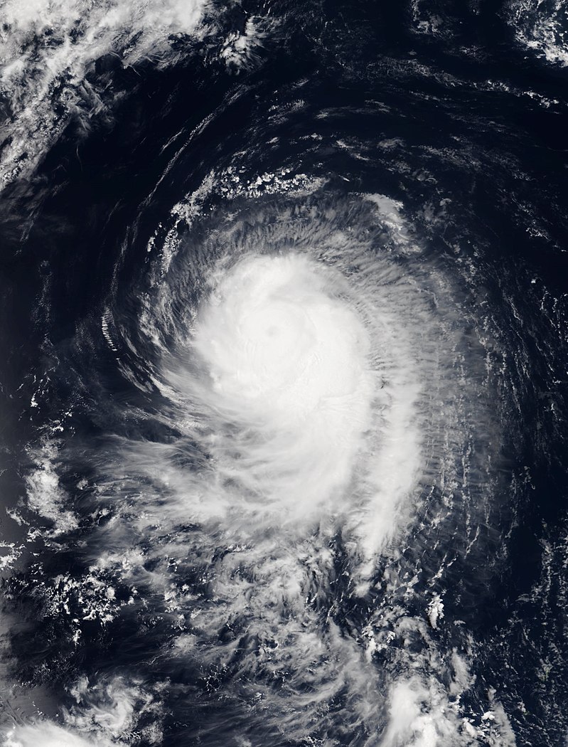
Hurricane Gabriel
| Category 4 hurricane (SSHWS) | |||
|---|---|---|---|
| |||
| Duration | September 3 – September 15 | ||
| Peak intensity | 140 mph (220 km/h) (1-min) 937 mbar (hPa) | ||

On August 31, after weeks of no activity, an potential tropical cyclone formed near Munising, Michigan. This potential tropical cyclone had caused rip current warnings to be issued along the coasts from Marquette to Grand Marais. On September 3, the potential tropical cyclone became a tropical storm and was named Gabriel. On September 5, Gabriel continued to slowly strengthen, just as it was beginning its curvature to the north, and the first watches were issued for parts of Coastal Ontario. Slow strengthening occurred over the next few days, as the storm was slowly moving to the north-northeast. Finally, on September 10, Gabriel strengthened into a hurricane. Almost simultaneously, the rate of strengthening began to rapidly increase. By the early morning hours of September 11, Gabriel had strengthened into the strongest storm of the season, and was continuing its intensification. The winds were at 125 mph and the pressure was at 944 millibars. An evacuation was ordered for Heron Bay and Marathon, Ontario, which had experienced an evacuation order a year before with Hurricane Lloyd, the strongest hurricane recorded in the basin. The mayor of Marathon had declared that anyone who stayed behind was most likely going to get trapped from flooding, due to the slowing movement of the storm as it was approaching land. On September 12, Gabriel reached its peak intensity before striking the coast just east of Neys, Ontario. The northeastern quadrant of the eyewall struck Marathon directly, causing extreme destruction. >$1 billion in damages occurred, along with 3 fatalities. Gabriel continued inland as it sped through the region. A brown-ocean effect occurred overland, and Gabriel strengthened back into a tropical storm. On September 15, Gabriel hit the Hudson Bay and almost immediately dissipated due to extremely frigid waters. Gabriel became the very first Lake Superior storm to make it to the Hudson Bay without dissipating.
Other systems
On January 1, 2018, Tropical Storm Willow and Hurricane Adrian were both active from the 2017 Lake Superior hurricane season. Tropical Storm Willow quickly made landfall, causing dissipation just a few hours into the season. Hurricane Adrian posed a threat to Isle Royale, prompting hurricane warnings for the island. Hurricane Adrian became a Category 4 hurricane before striking Isle Royale, causing $2.5 billion in damages and 13 fatalities. Adrian dissipated on January 7.
Storm names
This is the third naming list, following Lists I and II. It will make its debut this season, and all storm names on this list will be used for the first time ever in the basin. Names that were not retired appeared again in 2024.
|
|
|
Retirement
On October 14, 2018, the Great Lakes Hurricane Committee retired the names Daphne and Gabriel after the damages and deaths they caused. They were replaced by the names Denise and Grant for the 2024 season.